Digitalisierung (Digitizer)
Das Digitizer-Element ermöglicht den Aufbau von Erfassungsoberflächen. Derzeit kann über eine YAML-Definition eine Erfassungsmaske für Punkte, Linien oder Flächen aufgebaut werden. Dabei wird bisher PostgreSQL als Datenquelle unterstützt. Oracle und SpatiaLite sind experimentell verfügbar. Die Entwicklung wurde so durchgeführt, dass die Erfassung auch auf andere Datenquellen wie z.B. OGC WFS erweitert werden kann.
Das Digitizer-Element bietet komplexe Editierfunktionalitäten an:
- Verschieben von Objekten
- Einfügen von Stützpunkten (Linien, Flächen)
- Erfassung von Flächen mit Enklaven und/oder Exklaven sowie Kreisen und Ellipsen
In Zusammenhang mit der Digitalisierung können für die Erfassung von dazugehörigen Sachdaten sehr komplexe Formulare generiert werden. Hierbei wurde sich an den Möglichkeiten, die in Mapbender 2.x zur Verfügung stehen, orientiert.
Folgende Optionen stehen für den Aufbau von Formularen zur Verfügung:
- Definition von mehreren Datenquellen für die Erfassung (diese werden über eine Selectbox zur Auswahl angeboten)
- Als Datenquelle kann eine Tabelle angesprochen werden, wobei auch nur eine Auswahl der Daten über einen Filter herangezogen werden kann
- Textfelder
- Selectboxen, Multiselectboxen (Füllen der Auswahlbox über eine feste Definition von Werten in der YAML-Definition oder über ein Select auf eine Tabelle)
- Radiobuttons, Checkboxen
- Textblöcke
- Datumsauswahl
- Dateiupload
- Definition von Reitern
- Definition von Trennlinien
- Definition von beschreibenden Texten
- Pflichtfelder, Definition von regulären Ausdrücken für die Formatvorgabe des Feldinhalts
- Hilfetexte
Konfiguration
Das Element kann in der Sidepane eingebettet oder über eine Schaltfläche als Dialog aufgerufen werden.
Der Digitizer benötigt einen Zugriff auf die Datenbank, in der die zu editierenden Tabellen liegen. Sie müssen dazu einen Datenbankzugriff konfigurieren. Mehr zu diesem Thema finden Sie unter http://doc.mapbender3.org/de/book/database.html
Die Definition des Digitizers wird in einer YAML syntax durchgeführt. Hier definieren Sie die Datenbankverbindung, die editierbaren Felder, das Formular für die Anzeige und andere Verhaltensweisen.
Die Element Definitionen im Web-interface sind:
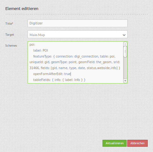
YAML-Definition für das Element digitizer in der Sidepane in der mapbender.yml:
sidepane:
    digitizer:
        class: Mapbender\DigitizerBundle\Element\Digitizer
        title: Digitalisation
        target: map
        schemes:
            ...
YAML-Definition für das Element digitizer in der Textarea unter schemes:
poi:
label: point digitizing
maxResults: 1500
featureType:
connection: search_db
table: poi
uniqueId: gid
geomType: point
geomField: geom
srid: 4326
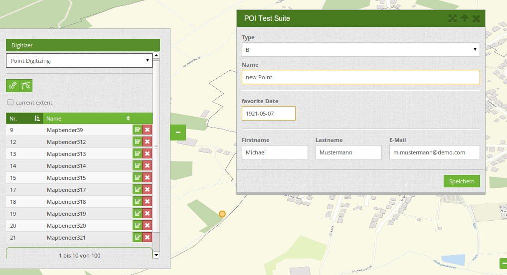
openFormAfterEdit: true
popup:
title: point test suite
width: 500px
tableFields: {gid: {label: Nr.}, name: {label: Name}}
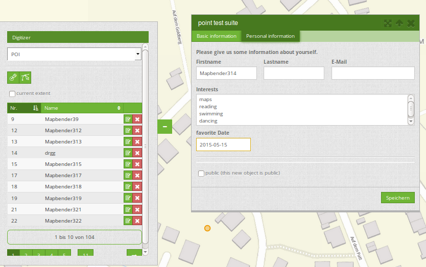
formItems:
- type: tabs
children:
- type: form
title: Basic information
css: {padding: 10px}
children:
- type: label
title: Welcome to the digitize demo. Try the new Mapbender3 feature!
- type: input
title: Name
mandatory: true
name: name
mandatoryText: Please give a name to the poi.
infoText: "Help: Please give a name to the new object."
- type: input
title: Title
mandatory: false
name: title
mandatoryText: Please give a title to the poi.
- type: textArea
name: abstract
title: Abstract
placeholder: 'please edit this field'
- type: select
title: Type
name: type
options: {A:A, B:B, C:C, D:D, E:E}
- type: breakLine
- type: form
title: Personal information
css: {padding: 10px}
children:
- type: label
title: Please give us some information about yourself.
- type: fieldSet
children:
- type: input
title: Firstname
name: firstname
css: {width: 30%}
- type: input
title: Lastname
name: lastname
css: {width: 30%}
- type: input
title: E-Mail
name: email
css: {width: 40%}
- type: select
multiple: true
title: Interests
name: interests
options: {maps:maps, reading:reading, swimming:swimming, dancing:dancing, beer:beer, flowers:flowers}
- type: date
title: favorite Date
name: date_favorite
mandatory: true
css: {width: 25%}
- type: breakLine
- type: breakLine
- type: checkbox
name: public
value: true
title: public (this new object is public)
line:
label: line digitizing
maxResults: 1500
featureType:
connection: search_db
table: lines
uniqueId: gid
geomType: line
geomField: geom
srid: 4326
openFormAfterEdit: true
popup:
title: line test suite
width: 500px
tableFields: {gid: {label: Nr.}, name: {label: Name}}
formItems:
- type: form
title: Basic information
css: {padding: 10px}
children:
- type: label
title: Welcome to the digitize demo. Try the new Mapbender3 feature!
- type: input
title: Name
mandatory: true
name: name
mandatoryText: Please give a name to the new object.
infoText: "Help: Please give a name to the new object."
- type: select
title: Type
name: type
options: {A:A, B:B, C:C, D:D, E:E}
polygon:
label: polygon digitizing
maxResults: 1500
featureType:
connection: search_db
table: polygons
uniqueId: gid
geomType: polygon
geomField: geom
srid: 4326
openFormAfterEdit: true
allowDelete: false
toolset:
- type: drawPolygon
- type: drawRectangle
- type: drawDonut
- type: removeSelected
popup:
title: polygon test suite
width: 500px
tableFields: {gid: {label: Nr.}, name: {label: Name}}
formItems:
- type: form
title: Basic information
css: {padding: 10px}
children:
- type: label
title: Welcome to the digitize demo. Try the new Mapbender3 feature!
- type: input
title: Name
mandatory: true
name: name
mandatoryText: Please give a name to the new object.
infoText: "Help: Please give a name to the new object."
- type: select
title: Type
name: type
options: {A:A, B:B, C:C, D:D, E:E}
Definition Popup
popup:
    # Options description:
    # http://api.jqueryui.com/dialog/
    title: POI                                     # define the title of the popup
    height: 400
    width: 500
    # modal: true
    # position: {at: "left+20px",  my: "left top-460px"}
Definition on Dateireitern (type tabs)
formItems:
   - type: tabs
     children:
       - type: form
         title: Basic information
         css: {padding: 10px}
         children:
             - type: label
               title: Welcome to the digitize demo. Try the new Mapbender3 feature!
               ...
Definition von Textfeldern (type input)
- type: input                    # element type definition
  title: Title for the field      # labeling (optional)
  mandatory: true                # mandatpory field (optional)
  name: column_name              # reference to table column (optional)
  cssClass: 'input-css'          # additional css definition (optional)
  value: 'default Text'          # define a default value  (optional)
  placeholder: 'please edit this field' # placeholder appears in the field as information (optional)
Definition von Auswahlboxen (selectbox oder multiselect (type select))
- type: select                     # element type definition
  title: select some types         # labeling (optional)
  name: my_type                    # reference to table column (optional)
  multiple: false                  # define a multiselect, default is false
  options:                         # definition of the options (key, value)
      1: pub
      2: bar
      3: pool
      4: garden
      5: playground
- type: select                       # element type definition
  title: select some types           # labeling (optional)
  name: my_type                      # reference to table column (optional)
  multiple: true                     # define a multiselect, default is false
  options: [1: pub, 2: bar, 3: pool] # definition of the options (key, value)
Füllen der Auswahlboxen über eine SQL Abfrage
- type: select                     # element type definition
  title: select some types         # labeling (optional)
  name: my_type                    # reference to table column
  connection: connectionName       # Define a connection selectbox via SQL
  sql: 'SELECT DISTINCT keyName, value FROM tableName' # get the options of the
Definition von Texten (type label)
- type: label                        # element type definition, will write a text
  title: 'Please give information about the poi.' # define a text
Definition of a textarea (type textarea)
- type: textarea
  title: Bestandsaufnahme Bemerkung
Definition of a breakline (type breakline)
- type: breakline # element type definition, will draw a line
Definition of a checkbox (type checkbox)
- type:  checkbox
  title: Is this true?
  name:  public
  value: true
Definition von Pflichtfeldern
mandatory: true                    # true - field has to be set. Else you can't save the object. Regular expressions are possible too - see below.

mandatory: /^\w+$/gi               # You can define a regular expression to check the input for a field. You can check f.e. for email or numbers. Read more http://wiki.selfhtml.org/wiki/JavaScript/Objekte/RegExp
# Check if input is a number
mandatory: /^[0-9]+$/
mandatoryText: Bitte die Zahl Eingeben!


mandatorytitle: Please chose a type! # define a text that will be displayed if the field is not set.
Definition von Feldern für den Dateiupload
- type: upload
  title: upload an image
  name: file1
  path: digitizer           # base location is "web/uploads", like this the files are saved at web/uploads/digitizer, also absolute path is possible like /data/webgis/digitizer
  format: %gid%-%name% (%name% is file1, %gid% - is ID fieldname)
  url:  /digitizer/         # optional, if ALIAS is defined
  allowedFormats: [jpg,png,gif,pdf]
Definition von Datumfeldern (Datepicker)
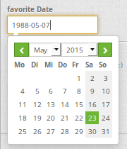
type: datepicker               # on click in the textfield a datepicker will open
value: 2015-01-01              # define a start value for the datepicker (optional)
format: YYYY-MM-DD             # define a dateformat (optional), default is YYYY-MM-DD
Definition von Gruppierungen (type: fieldSet)
- type: fieldSet
  children:
      - type: input
        title: Firstname
        name: firstname
        css: {width: 30%}
      - type: input
        title: Lastname
        name: lastname
        css: {width: 30%}
      - type: input
        title: E-Mail
        name: email
        css: {width: 40%}
Definition von Toolset Types
Toolset types
- drawPoint - Punkt erstellen
- drawLine - Line erstellen
- drawPolygon - Polygone erstellen
- drawRectangle - Rechteck erstellen
- drawCircle - Circle erstellen
- drawEllipse - Ellipse erstellen
- drawDonut - Donut erstellen oder die bestehende Geometrien editieren
- modifyFeature - Geometrien einzelne Punkte verschieben
- moveFeature - Geometrien verschieben
- selectFeature - Geometrien de/selektieren
- removeSelected - die selektierten löschen
- removeAll - alle Löschen (aus dem Layer)
Definition of toolset types
polygon:
    label: polygon digitizing
    maxResults: 1500
    featureType:
        connection: search_db
        table: polygons
        uniqueId: gid
        geomType: polygon
        geomField: geom
        srid: 4326
    openFormAfterEdit: true
    allowDelete: false
    toolset:
        - type: drawPolygon
        - type: drawRectangle
        - type: drawDonut
        - type: removeSelected
Definition des aktuellen Kartenausschnitts
searchType:
- all
- currentExtent (default)
openFormAfterEdit: true
searchType: currentExtent # currentExtent|all - default is currentExtent
featureType:
    connection: search_db
    table: lines
    uniqueId: gid
    geomType: line
    geomField: geom
    srid: 4326
    fields: "*"
Definition des Verhaltens des Popup
Bei true (default): nach dem Anlegen einer Geometrie wird sofort das Formular zur Sachdateneingabe geöffnet.
poi:
    label: point digitizing
    maxResults: 1500
    featureType:
        [...]
    openFormAfterEdit: true
    popup:
        [...]
Class, Widget & Style
- Class: Mapbender\CoreBundle\Element\Digitizer
- Widget: mapbender.element.digitizer.js
- Style: mapbender.elements.css