Digitizer
The Digitizer element allows building editing-interfaces. Currently you can build up your interface for point, line and point editing with a YAML-definition. Right now PostgreSQL is supported as a database. Oracle and SpatialLize can be used experimentally. The development of the data-sources allow other data sources so that it can be extended to support - for example - OGC WFS services.
The Digitizer-Element offers complex editing functionality:
- move objects
- add vertices (lines, polygons)
- generation of enclaves, exclaves, circles and ellipses
You can define very complex formss for the attributes. This follows the capabilities of Mapbender 2.x.
The following option for the construction of the forms are available:
- define more then one feature types for digitalisation. You can switch from one feature type to the other with a select box
- use a table as source. You can also define a filter to get a subset of the table
- textfields
- Selectboxes, Multiselectboxes
- Radiobuttons, Checkboxes
- Textareas
- Datepicker
- File upload
- Definition of tabs
- Definition breaklines
- Definition of Text
- Mandatory fields, regular expressions to valida the content are possible
- Help textes
Configuration
You can use the element in the sidepane or as a dialog with a button.
The Ditigitzer needs access to a database where the editable tables are. You have to define a new database configuration to be able to connect with the geo database. Read more about this at http://doc.mapbender3.org/en/book/database.html
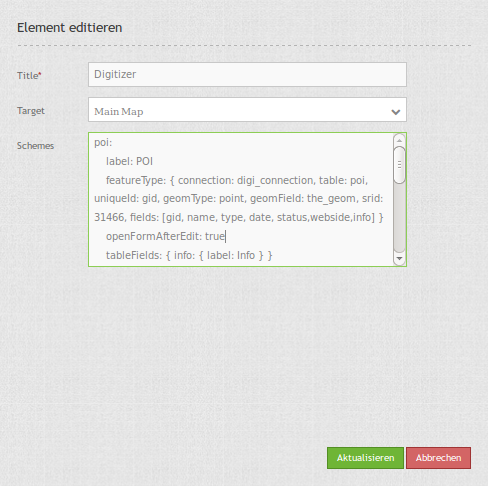
The definition of the digitizer is done in YAML syntax in the textarea configuration at schemes. Here you define the database connection, the editable table, the form to display the table, the attribute form and other behaviour.
Element definition in web interface in the configuration area:
YAML-Definition for the element digitizer in mapbender.yml:
sidepane:
    digitizer:
        class: Mapbender\DigitizerBundle\Element\Digitizer
        title: Digitalisation
        target: map
        schemes:
            ...
YAML-Definition for the element digitizer in the textarea schemes:
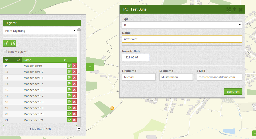
poi:
label: point digitizing
maxResults: 1500
featureType:
connection: search_db
table: poi
uniqueId: gid
geomType: point
geomField: geom
srid: 4326
openFormAfterEdit: true
popup:
title: point test suite
width: 500px
tableFields: {gid: {label: Nr.}, name: {label: Name}}
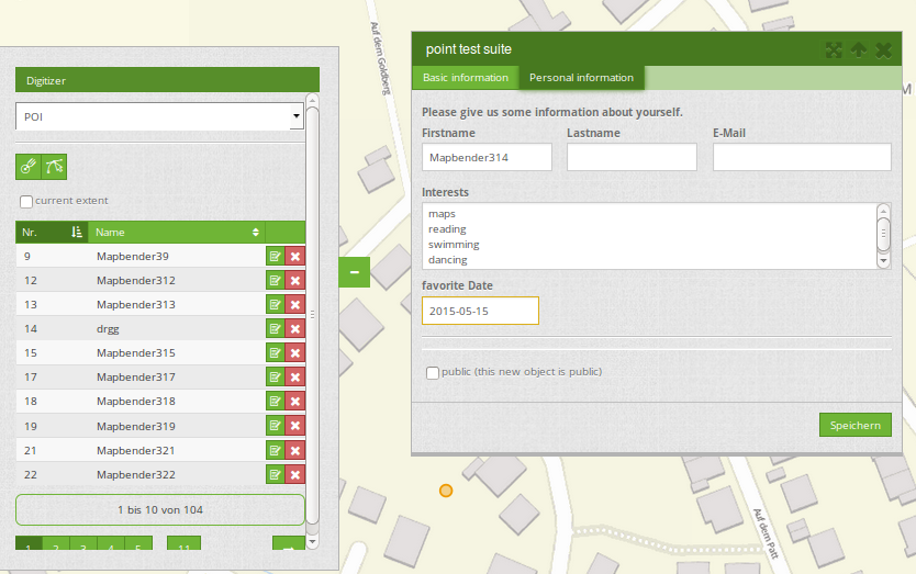
formItems:
- type: tabs
children:
- type: form
title: Basic information
css: {padding: 10px}
children:
- type: label
title: Welcome to the digitize demo. Try the new Mapbender3 feature!
- type: input
title: Name
mandatory: true
name: name
mandatoryText: Please give a name to the poi.
infoText: "Help: Please give a name to the new object."
- type: input
title: Title
mandatory: false
name: title
mandatoryText: Please give a title to the poi.
- type: textArea
name: abstract
title: Abstract
placeholder: 'please edit this field'
- type: select
title: Type
name: type
options: {A:A, B:B, C:C, D:D, E:E}
- type: breakLine
- type: form
title: Personal information
css: {padding: 10px}
children:
- type: label
title: Please give us some information about yourself.
- type: fieldSet
children:
- type: input
title: Firstname
name: firstname
css: {width: 30%}
- type: input
title: Lastname
name: lastname
css: {width: 30%}
- type: input
title: E-Mail
name: email
css: {width: 40%}
- type: select
multiple: true
title: Interests
name: interests
options: {maps:maps, reading:reading, swimming:swimming, dancing:dancing, beer:beer, flowers:flowers}
- type: date
title: favorite Date
name: date_favorite
mandatory: true
css: {width: 25%}
- type: breakLine
- type: breakLine
- type: checkbox
name: public
value: true
title: public (this new object is public)
line:
label: line digitizing
maxResults: 1500
featureType:
connection: search_db
table: lines
uniqueId: gid
geomType: line
geomField: geom
srid: 4326
openFormAfterEdit: true
popup:
title: line test suite
width: 500px
tableFields: {gid: {label: Nr.}, name: {label: Name}}
formItems:
- type: form
title: Basic information
css: {padding: 10px}
children:
- type: label
title: Welcome to the digitize demo. Try the new Mapbender3 feature!
- type: input
title: Name
mandatory: true
name: name
mandatoryText: Please give a name to the new object.
infoText: "Help: Please give a name to the new object."
- type: select
title: Type
name: type
options: {A:A, B:B, C:C, D:D, E:E}
polygon:
label: polygon digitizing
maxResults: 1500
featureType:
connection: search_db
table: polygons
uniqueId: gid
geomType: polygon
geomField: geom
srid: 4326
openFormAfterEdit: true
allowDelete: false
toolset:
- type: drawPolygon
- type: drawRectangle
- type: drawDonut
- type: removeSelected
popup:
title: polygon test suite
width: 500px
tableFields: {gid: {label: Nr.}, name: {label: Name}}
formItems:
- type: form
title: Basic information
css: {padding: 10px}
children:
- type: label
title: Welcome to the digitize demo. Try the new Mapbender3 feature!
- type: input
title: Name
mandatory: true
name: name
mandatoryText: Please give a name to the new object.
infoText: "Help: Please give a name to the new object."
- type: select
title: Type
name: type
options: {A:A, B:B, C:C, D:D, E:E}
Definition of the popup
popup:
    # Options description:
    # http://api.jqueryui.com/dialog/
    title: POI                                     # define the title of the popup
    height: 400
    width: 500
    # modal: true
    # position: {at: "left+20px",  my: "left top-460px"}
Definition of tabs (type tabs)
formItems:
   - type: tabs
     children:
       - type: form
         title: Basic information
         css: {padding: 10px}
         children:
             - type: label
               title: Welcome to the digitize demo. Try the new Mapbender3 feature!
               ...
Definition of a textfield (type input)
- type: input                    # element type definition
  title: Title for the field      # labeling (optional)
  mandatory: true                # mandatpory field (optional)
  name: column_name              # reference to table column (optional)
  cssClass: 'input-css'          # additional css definition (optional)
  value: 'default Text'          # define a default value  (optional)
  placeholder: 'please edit this field' # placeholder appears in the field as information (optional)
Definition of a selectbox or multiselect (type select)
- type: select                     # element type definition
  title: select some types         # labeling (optional)
  name: my_type                    # reference to table column (optional)
  multiple: false                  # define a multiselect, default is false
  options:                         # definition of the options (key, value)
      1: pub
      2: bar
      3: pool
      4: garden
      5: playground
- type: select                       # element type definition
  title: select some types           # labeling (optional)
  name: my_type                      # reference to table column (optional)
  multiple: true                     # define a multiselect, default is false
  options: [1: pub, 2: bar, 3: pool] # definition of the options (key, value)
Get the options for the select box via SQL
- type: select                     # element type definition
  title: select some types         # labeling (optional)
  name: my_type                    # reference to table column
  connection: connectionName       # Define a connection selectbox via SQL
  sql: 'SELECT DISTINCT keyName, value FROM tableName' # get the options of the
Definition of a text (type label)
- type: label                        # element type definition, will write a text
  title: 'Please give information about the poi.' # define a text
Definition of a textarea (type textarea)
- type: textarea
  title: Bestandsaufnahme Bemerkung
Definition of a breakline (type breakline)
- type: breakline # element type definition, will draw a line
Definition of a checkbox (type checkbox)
- type:  checkbox
  title: Is this true?
  name:  public
  value: true
Definition of a mandatory field
mandatory: true                    # true - field has to be set. Else you can't save the object. Regular expressions are possible too - see below.

mandatory: /^\w+$/gi               # You can define a regular expression to check the input for a field. You can check f.e. for email or numbers. Read more http://wiki.selfhtml.org/wiki/JavaScript/Objekte/RegExp
# Check if input is a number
mandatory: /^[0-9]+$/
mandatoryText: Bitte die Zahl Eingeben!


mandatorytitle: Please chose a type! # define a text that will be displayed if the field is not set.
Definition of a datepicker
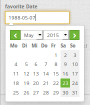
type: datepicker               # on click in the textfield a datepicker will open
value: 2015-01-01              # define a start value for the datepicker (optional)
format: YYYY-MM-DD             # define a dateformat (optional), default is YYYY-MM-DD
Definition of element groups (type: fieldSet)
- type: fieldSet
  children:
      - type: input
        title: Firstname
        name: firstname
        css: {width: 30%}
      - type: input
        title: Lastname
        name: lastname
        css: {width: 30%}
      - type: input
        title: E-Mail
        name: email
        css: {width: 40%}
Definition of a file upload field
- type: upload
  title: upload an image
  name: file1
  path: digitizer           # base location is "web/uploads", like this the files are saved at web/uploads/digitizer, also absolute path is possible like /data/webgis/digitizer
  format: %gid%-%name% (%name% is file1, %gid% - is ID fieldname)
  url:  /digitizer/         # optional, if ALIAS is defined
  allowedFormats: [jpg,png,gif,pdf]
Definition of toolset types
Toolset types
- drawPoint - draw point
- drawLine - draw a line
- drawPolygon - draw polygon
- drawRectangle - draw rectangle
- drawCircle - draw circle
- drawEllipse - draw ellipse
- drawDonut - draw a donut (enclave)
- modifyFeature - move vertices of a geometry
- moveFeature - move geometry
- selectFeature - geometry de/select
- removeSelected - delete selected geometry
- removeAll - remove all geometries
Definition of toolset types
polygon:
    label: polygon digitizing
    maxResults: 1500
    featureType:
        connection: search_db
        table: polygons
        uniqueId: gid
        geomType: polygon
        geomField: geom
        srid: 4326
    openFormAfterEdit: true
    allowDelete: false
    toolset:
        - type: drawPolygon
        - type: drawRectangle
        - type: drawDonut
        - type: removeSelected
Definition of current extent
searchType:
- all
- currentExtent (default)
openFormAfterEdit: true
searchType: currentExtent # currentExtent|all - default is currentExtent
featureType:
    connection: search_db
    table: lines
    uniqueId: gid
    geomType: line
    geomField: geom
    srid: 4326
    fields: "*"
Definition of popup behaviour
Set to true (default): after creating a geometry the form popup is opened automatically to insert the attribute data.
poi:
    label: point digitizing
    maxResults: 1500
    featureType:
        [...]
    openFormAfterEdit: true
    popup:
        [...]
Class, Widget & Style
- Class: Mapbender\CoreBundle\Element\Digitizer
- Widget: mapbender.element.digitizer.js
- Style: mapbender.elements.css